It may not be easy to comprehend nowadays that the Bridle Stile was once part of the principal route from Sheffield to London. There was an alternative, through Coal Aston to Marsh Lane and thence to Eckington, but the gradients on that route were considered far more arduous.
The Bridle Stile route led from Little Sheffield (perhaps better known today as Highfields) through Heeley and Gleadless to Mosborough, Eckington, and beyond. Notes from the records of the Wortley family of Wharncliffe Lodge in Sheffield, between 1731-1756, describe one such journey ‘From the Lodge to Eckington 12 miles thus: To Jessop’s [Broom Hall] 6 miles, from Mr. Jessop’s to Little Sheffield 1, Hely [Heeley] 1, Gladeley [Gleadless] 1, Marsburgh [Mosborough] 2, Eckington 1’. The 2 miles from Gleadless to Mosborough would have included the Bridle Stile. The mode of transport would have been horseback; carriages were not widely adopted until much later.
The name Bridle Stile is derived from the Middle English ‘bridel’, meaning headgear of a horse, relating to the verb ‘bregdan’, which means to move quickly, and the Old English ‘stig’, meaning path (language in everyday use before 900 AD). The route along the Ridgeway probably follows an earlier way stretching back to the prehistoric period.
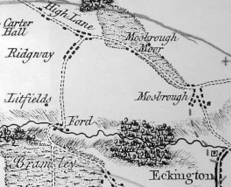
Burdett’s Map of Derbyshire (1791), one of the earliest complete maps of the county (see extract in Figure 1), depicts the route of the Bridle Stile from High Lane to Mosborough village, notably before the A6135 High Street/Mosborough Moor Turnpike Road was constructed. Records of the Eckington Manor Court in 1823 distinguish between the two routes, The Turnpike Road to the north and the ‘High Road’ (Bridle Stile) to the south.